


The quest for accuracy

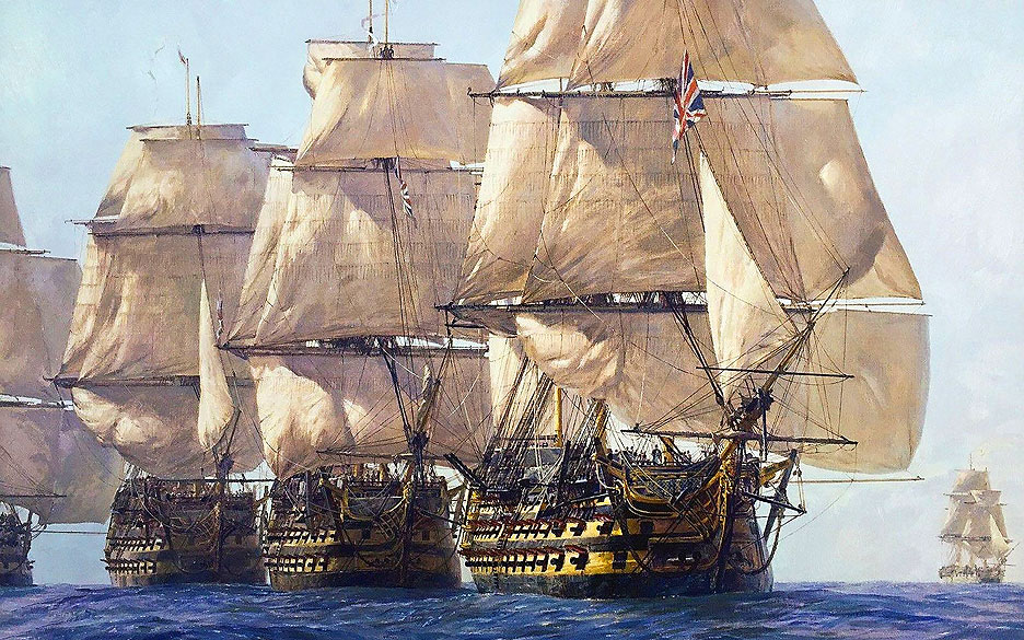
In the late 16th century, all major European powers were locked in fierce competition to claim as many new territories as possible. Although the British fleet was among the largest and strongest in the world, its sailors faced the same challenge as everyone else: navigating the oceans was extremely difficult and dangerous because there were no visible landmarks on the open sea. We are used to globes marked with a grid of parallels and meridians. The coordinates of any object—or any ship—can be described by latitude and longitude. Latitude is the distance from the equator; longitude is the distance from an imaginary zero line running from the North to the South Pole—the prime meridian.
Determining latitude was relatively straightforward using a sextant to measure the angular height of a star, such as Polaris, above the horizon, or the angle between the horizon and the sun. The larger the angle, the closer you are to the equator.
But how to determine longitude? Which meridian are you on? At the time, the only practical method was to use the moon and stars as reference points, relying on star charts compiled by astronomers. This required extremely complex calculations, which were beyond most sailors (and could only be performed under a clear night sky). As a result, well into the 18th century, only a few bold adventurers dared to undertake long ocean voyages.

There was another way to determine longitude, but for centuries it remained purely theoretical. If you could accurately determine how the current time on a ship at sea differed from the current time in the home port, you could then calculate the longitude. How does that work? Since the Earth’s circumference is 360° and it completes one full rotation in 24 hours, the Earth turns 15° relative to the sun each hour. In other words, the sun appears to shift 15° westward along the ecliptic every hour. Imagine an English captain sailing from Plymouth to America who always knows the current time in the port of departure. By also determining the local time on his ship, he calculates the difference between his local time at sea (say, 11:00 PM) and the current time in Plymouth (say, 4:00 AM)—a difference of 5 hours. Thus, he knows the ship has moved 75° west of Plymouth: 15° × 5 hours = 75°. Simple enough!
The catch is that this method works only if you can determine very accurate time, which was impossible using astronomical calculations alone. Moreover, the mechanical clocks of the day were wholly inadequate: they were not accurate enough, and their accuracy deteriorated during a voyage because changes in temperature and humidity affected the dimensions of their components. It is easy to see why this method was impractical at the time.

So, as long as mariners could not determine their position while navigating, the risk of arriving somewhere unintended—or simply perishing at sea, which unfortunately happened far more often—remained enormous.
On October 22, 1707, a fleet of 21 British ships returning from the Mediterranean after a failed attempt to capture the French port of Toulon entered the waters of the English Channel. A storm was raging. Admiral Cloudesley Shovell gathered his officers to determine the fleet’s position. They all agreed that the ships had already reached the island of Ushant off the coast of French Brittany. In reality, they were nearly 200 kilometres further north, near the British Isles of Scilly, and rapidly approaching the rocks surrounding those islands. Around eight in the evening, crews on several vessels spotted the rocks and fired warning shots.
But it was too late. Four ships, including the flagship HMS Association, were wrecked. Over 2,000 sailors, including Admiral Shovell, perished, and a cargo of gold and silver sank to the bottom. Only 25 men survived. It was the Royal Navy’s largest non-combat loss in a long time. And the fact that the disaster occurred in well-known British waters only underscored how dangerous the inability to determine longitude accurately really was.

The catastrophe made such a deep impression on the country that the British finally took the problem seriously. Seven years later, Parliament passed the “Act for Providing a Publick Reward for such Person or Persons as shall Discover the Longitude at Sea.” It offered a generous prize to anyone who could find a practical and feasible solution for determining longitude at sea to within half a degree (at the equator, this equals 30 nautical miles, or about 56 kilometres). This essentially meant creating extremely accurate clocks capable of maintaining stable timekeeping in harsh marine conditions.
The stakes were very high: the nation that learned to determine its ships’ coordinates would gain a colossal advantage at sea. Any other prize paled in comparison. That is why the British offered a reward of £20,000—equivalent to 150 kilograms of gold! Unprecedented generosity. The dream of such wealth spurred many clockmakers to action. One unusual contender for the prize was a young Englishman with no formal training in clockmaking, named John Harrison.
He was born in 1693, the son of a carpenter. He followed his father’s trade but was also interested in music and clockwork. Legend has it that as a child, he fell ill with smallpox and was given a clock to keep him occupied. That is how his passion began—taking clocks apart and then putting them back together. Harrison was essentially a self-taught clockmaker; there is no record of him ever being apprenticed to a master. He built his first clock at the age of 20, and astonishingly, entirely out of wood. As a carpenter like his father, he had no other material available.

In 1730, the still-unknown Harrison entered the race to create a clock that would not lose accuracy during a long stay aboard a moving ship, regardless of rolling, temperature changes, pressure, humidity, and the corrosive effects of salt air.
The fact that Harrison was self‑taught worked to his advantage. Most professionals, knowing that accuracy had to stay within three seconds per day over a six‑week voyage, considered the task impossible, because they understood how difficult that was. Harrison, on the other hand, could not appreciate the full difficulty, so he saw the challenge as simply another engineering problem.
The inventor had limited funds and almost no access to scientific equipment, so he had to approach the problem creatively. For instance, to test how temperature and humidity changes affected the clock’s accuracy, he simply created the conditions in his own home: lighting a fire in one room and creating a draft in another.
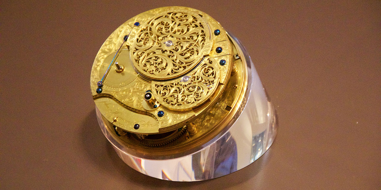
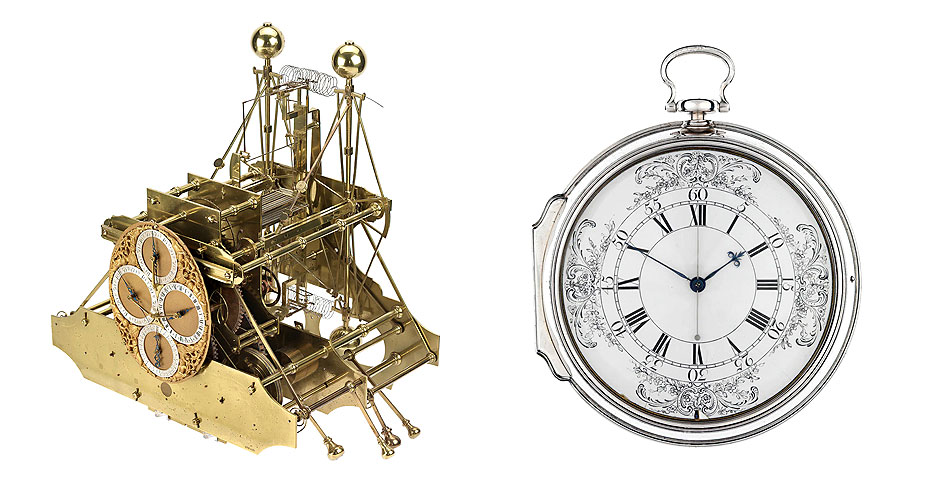
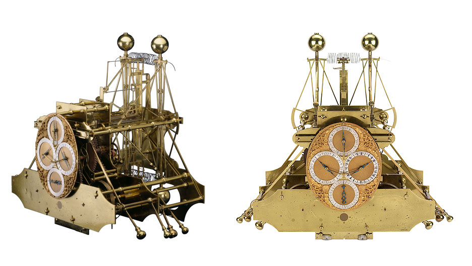
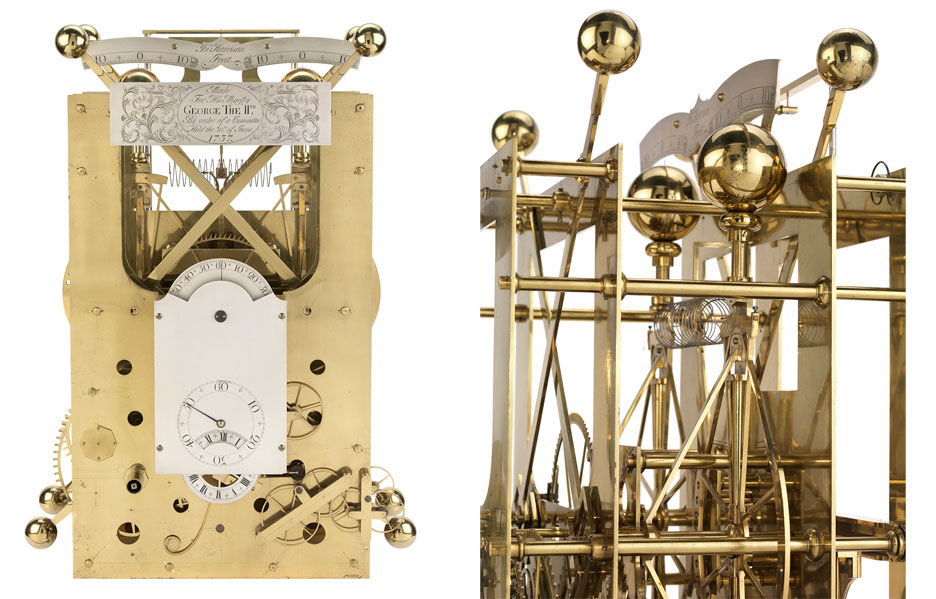
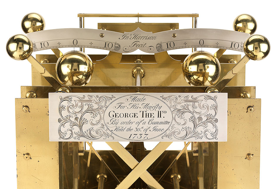
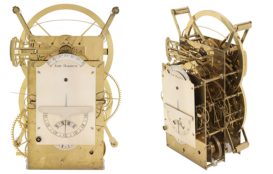
The requirements of the “Act for Providing a Publick Reward for the Discovery of the Longitude at Sea” were so demanding that John Harrison spent about 40 years developing his timepiece (the marine chronometer). He progressed from his first bulky marine chronometer (called H1) in 1735 to a successful fourth version (called H4), which resembled a large pocket watch and was completed in 1761.

It was decided to test H4 with utmost seriousness. It was sent from Portsmouth to Jamaica. Harrison was then 68 years old, so his son William accompanied the chronometer across the Atlantic to oversee the trial. The result exceeded all expectations: after a 61‑day voyage to Port Royal, Jamaica, through storms and rough seas, and after correcting for the initial rate error, the clock was found to be slow compared to astronomically determined time by just five seconds!
Such accuracy was unattainable for any stationary or portable clocks of that era. Moreover, the H4 model is still more accurate than almost all mechanical wristwatches produced in Switzerland today.
Unfortunately, after several decades of “struggle for accuracy,” Harrison now had to engage in a “struggle for the prize” against English bureaucracy. The Board of Longitude, which was authorised to award the prize, was sceptical of his solution. Deciding that the craftsman had simply been lucky, it refused to name him the winner. The Board demanded a second trial. In 1764, the clock proved its reliability and accuracy again, but even that did not convince the officials. Only through the intercession of George III, then King of England, did Harrison finally manage to have his ingenious invention recognised and receive the long‑deserved reward after forty years of trial and error and exhausting battles with bureaucrats. By then, the inventor was eighty years old, but he spent his last ten years in honour and wealth. By today’s standards, he would be a multimillionaire.

Harrison was justifiably proud of his invention, as reflected in one of his letters: “I think I may without vanity say that there is not any mechanical or mathematical thing in the world that is more beautiful or more curious than my clock and longitude chronometer.”
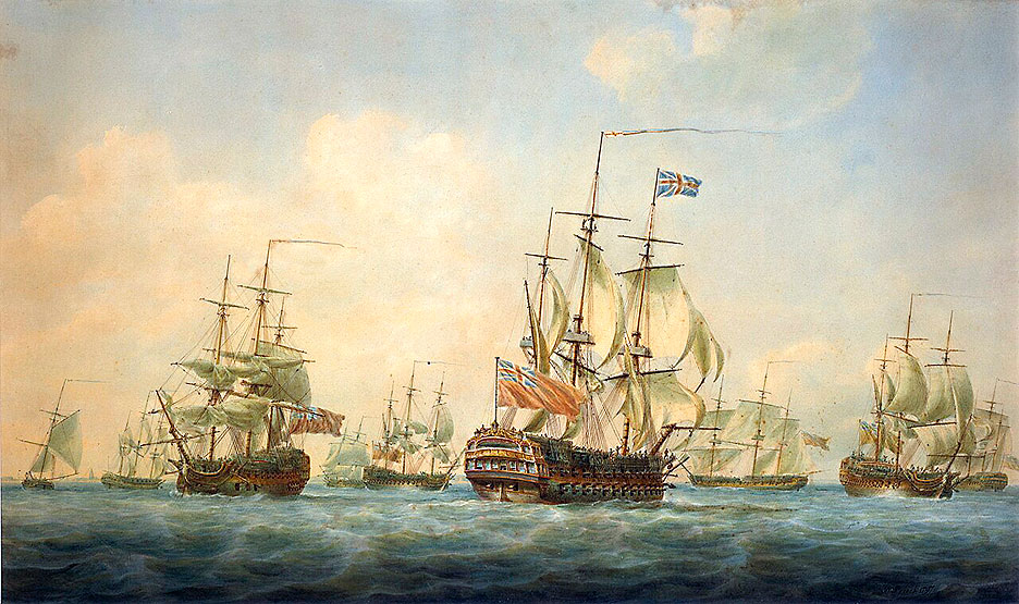
Because of the high cost of production, marine chronometers remained rare for a long time (their price could be up to a third of the cost of a ship). One of the first to use a marine chronometer was English Captain James Cook, one of the greatest explorers in history.
Thus, his monumental discoveries in the Pacific Ocean were partly thanks to an ultra‑accurate clock. With this clock, Cook could determine longitude and, therefore, his precise geographical position while sailing. Cook accurately charted the coasts of New Zealand and Australia, sailed around Antarctica, traversed the Northwest Passage between Russia and Alaska, and discovered many previously unknown islands, such as Hawaii, where he was killed by local inhabitants in 1779. The famous captain called his marine chronometer nothing less than his “faithful guide through capricious seas.”

Only by the 1820s were enough marine chronometers based on Harrison’s H4 design produced to meet demand, and their price fell to an affordable level. This was also helped by the British Parliament’s adoption of the “Chronometer Act” in 1825. The Act required that all British vessels, both military and civilian, be equipped with marine chronometers for accurate determination of longitude at sea.
Today, restored examples of Harrison’s chronometers H1, H2, H3, and H4 can be seen at the National Maritime Museum in Greenwich. For his invaluable contribution to horology and the building of the British Empire, Harrison was honoured with a memorial plaque in Westminster Abbey, located in the centre of the nave. The inscription reads: “JOHN ‘LONGITUDE’ HARRISON, CLOCKMAKER (1693–1776).”
Thanks to Harrison’s invention of the marine chronometer, the British military and merchant fleets gained a significant competitive advantage over the fleets of other sea powers: France, Spain, the Netherlands, and Russia. Great Britain—essentially a small island—became the undisputed mistress of the seas and oceans in the 19th century and built the largest global empire, which at its height included over 50 colonies on every ocean.
At its peak in the 19th and early 20th centuries, Great Britain ruled about a quarter of the world’s population and occupied roughly the same fraction of the Earth’s surface. Consequently, on some of its territories it was always day, while on others it might already be night. That is why it was called “the empire on which the sun never sets.”
Incidentally, at the height of its power, Britain perceived only one threat: Russia. Indeed, the Russian Empire was expanding in all directions: in Eastern Europe, the Baltic region, the Caucasus, Central Asia, Siberia, and even Alaska. Britain was particularly alarmed by Russia’s growing influence and power in Central Asia, as this expansion supposedly threatened its colony in India. This led to serious rivalry between the empires in the 19th century and greatly exacerbated their already existing historical mutual distrust.
One can catch an ironic twist of fate: while Great Britain today has lost the knowledge of how to produce the marine chronometers that once allowed it to rule the waves and build its empire on which the sun never set, Russia, as far as I know, is the only country that still knows how and continues to manufacture them. After World War II, production was established in the USSR at the Moscow Watch Factory “Polyot.” Although the factory itself no longer exists, the single workshop still in operation there is the workshop for making marine chronometers. Even today in Russia, in the age of GLONASS and GPS, a mechanical marine chronometer remains a mandatory instrument on large vessels and submarines, so that in the event of satellite navigation system failures, sailors can determine their longitude by calculating the precise time difference between the prime meridian and their current location.
So, thanks to a clock, Great Britain built the British Empire, which made Britain the most powerful economic power on earth and largely shaped the Western world as we know it today—a world that dominated for several centuries.


