


Spring at the end of the world

Officially, the name “Patagonia” is not on the maps of Chile and Argentina, the two countries that share this vast territory between themselves. As you know, they drew the border in the south along the 52nd parallel after long territorial conflicts. As a result of this decision, the Chileans got dense forests, fjords, and 80% of the Southern Glacial Plateau. The most famous glacier in Argentina, Perito Moreno, is named after the explorer Francisco Moreno, who defended the interests of his country.
Its size is modest compared to the scale of the Southern Plateau, but easy accessibility and well-established tourist infrastructure in Los Glaciares Park put it beyond competition—here you can go hiking in crampons on the glacier or simply stroll along a branching network of routes, equipped with observation decks in the most picturesque places, watching how pieces break off with a roar from an ice block the height of a 20-story building.
The classic route towards Chile takes four hours. Closer to the border, the landscape becomes more vivid. Green colour begins to win its place in the monotonous palette consisting of golden and ash brown. During the season, everything here is covered with daisies and lupins. And here we are at the very border, where eagle-eyed Chilean customs officers look for… forbidden fruits in luggage bags (fresh and dried fruits, along with other food, are on the list of prohibited items after weapons and before drugs).
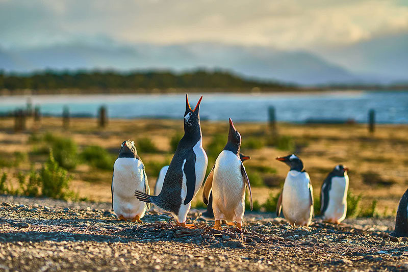
And now you are greeted by a region with the romantic name “Magallanes and Chilean Antarctica.” It is named after Ferdinand Magellan, just like that capricious strait where the waters of two oceans mix. The Chileans dedicated a lot to the great navigator; one can also recall the Magellanic forests in Southern Patagonia with the evergreen Nyirre beech tree and the Magellanic penguins that come here in the summer to raise their offspring.
Local residents proudly call themselves not just Chileans, but Magallanicos, and often hang a regional flag on their facades instead of the national one, and if there are two, then their own first.
The map of Chile is rounded and scattered in Patagonia with many islands, fjords, and channels. Often the names are literal translations of the original English, from Waste Bay to Sandy Point to Last Hope.
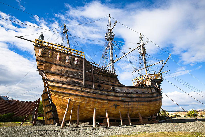
In general, traveling through Patagonia feels like being transported back to school for a geography lesson. Along the route, the names of Drake, Magellan and Darwin regularly appear. You can still get in touch with the world of great adventurers, travelers and naturalists today. Exact replicas of the Beagle and Magellan's carrack are on display at the Nao Museum in the vicinity of Punta Arenas.
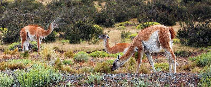
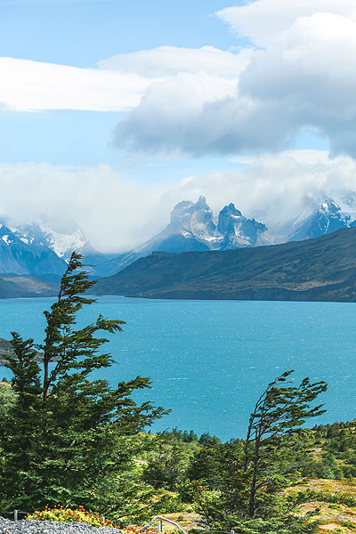
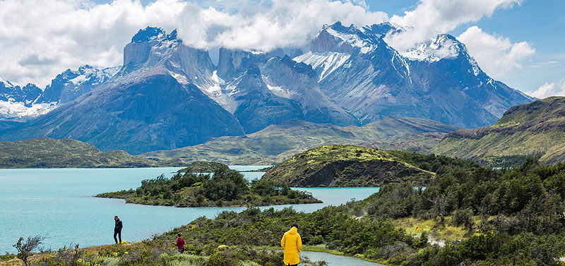
The pearl of Chilean Patagonia is Torres del Paine National Park, with an array of muscular mountains with sharp peaks. Here everyone will find something to their liking, both those who like multi-day hikes with tents and those who prefer to gaze at all this beauty from the balcony of a luxury hotel after a massage in a spa rather than forays into the bosom of nature. This is the habitat of wild pumas. Sometimes tourists were able to see the predator chasing a guanaco. Avid fishermen especially come here on vacation for one of the best spots in the world for hunting river trout.
The town closest to the park, Puerto Natales, is small and provincial, but as a “gateway to the park” it has acquired an important tourist status, which is confirmed by the airport that has appeared here, restaurants with an impressive receipt and exclusive souvenirs. Guests are greeted by the figure of a giant sloth, Mylodon, who lived here in the Pleistocene era. The cave where a fragment of his bone was found is located half an hour drive from the city.
Along with tourism, the region’s economy is boosted by salmon farms, whose gifts end up directly on restaurant plates. It must be said that the traditional Patagonian diet is based on lamb (a tribute to the gaucho traditions), but the gastronomic ball here is ruled by fish and seafood - king crab, Patagonian hake, sea bass.

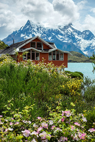
The main stronghold of exclusive tourism in Puerto Natales is The Singular Patagonia hotel in the village of Puerto Borjes, amidst the stunning landscape of the Patagonian fjords of Ultima Esperanza and the Andes. The stark red brick building was a meat processing plant a century ago, and giant cast iron wheels, damper ovens and intricately woven pipes are artfully incorporated into the interior. The rooms have 6-meter panoramic windows and offer magnificent views of the fjords.
On the morning of arrival, if you are lucky with the weather and the carabineros have not vetoed boat trips (in this part of Patagonia, calm and sunshine are considered lucky), you can go to a private island in the middle of the fjord.
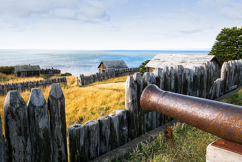
By the way, beautiful weather here is when the rain has stopped lashing you with a wet whip, and the wind strives not to tear out your soul, but only to carry away your glasses. It is impossible to predict the weather in southern Patagonia; the only thing you can be sure of is the wind. And Puerto Natales is just some flowers. On the southern tip of Patagonia, in the Cape Forward region, where the restored fort of the first settlers is located, the wind reaches such strength that it bends trees at an angle of 30 degrees.
An hour's journey from the hotel's pier, the island comes into view with a hill from which, on a clear day, you can see the spectacular tongue of the Serrano hanging glacier. “You're lucky; the weather is beautiful today,” a man in a cowboy hat and with a typically Irish surname will tell you, rocking in the saddle. Patagonia, as you know, was developed by Welsh and Irish colonists. You can ride around the island on horseback and then have lunch in the central building with a guest dining room near a hot cast-iron stove.
The family got the island as a result of the division of lands that were owed to the colonists during the “sheep boom.” Today's owners have lived in the city for a long time. They complain about the uncontrolled proliferation of introduced rodents, which are difficult to control. As a result, the land is dotted with burrows, which makes it unsuitable for cattle breeding.
Few continue the work of their ancestors today. They manage farms with no idea how to get rid of hundreds of hectares of unnecessary land, a troublesome inheritance in an era of total decline in sheep farming. Over the course of a century and a half, the gaucho profession itself has become a relic, interesting for ethnographers, but completely impractical.

The most enterprising heirs give tourists access to their trout-filled rivers, hold sheep-shearing shows in barns (a spectacle not for the faint of heart), and serve dinners with the inevitable lamb in family dining rooms furnished with dilapidated 19th-century furniture that has a strange charm in these sub-Antarctic latitudes.
Chile has elevated land ownership to an untouchable cult. There is not a piece of land in Patagonia that has not been assigned to a private owner since the days when immigrants, encouraged by the Chilean authorities, came here from all over the Old World, covering the long journey across the Atlantic.
In addition to people from Foggy Albion, Croats flocked here—in the city of Punta Arenas, there was a newspaper and radio in the Croatian language, a secular club, and the Sokol sports stadium. Today's 36-year-old president of Chile with the Croatian surname Borich is from Punta Arenas. So the owners of the island have a family tree hanging on their wall, where the Irish and Croatian branches are intertwined.
In Punta Arenas, the elegant mansion of Sarah Brown, from a family of Latvian Jews, founder of a sheep farming company in the Tierra del Fuego archipelago and wife of tycoon José Nogueira, was preserved—this was a family that influenced the life of the entire region, and sheep are even depicted on his tombstone.

The history of the development of these lands is a real goldmine for adventure film directors! There will be enough material for more than one series in the Western style, only in other settings, no less majestic than the prairies and canyons of the Wild West. The Chileans presented their first attempt at the big screen, Felipe Galvez's Los colonos, at this year's Cannes Film Festival, and it's surprising that they didn't do it earlier.
Patagonia is divided not only into Chilean and Argentinean but also into North and South with noticeable differences in natural landscapes. Their geographical isolation remained insurmountable for a long time. The main routes of communication were by sea, and only in the second half of the twentieth century did roads appear, such as Pinochet's famous southern highway, Carretera Austral.
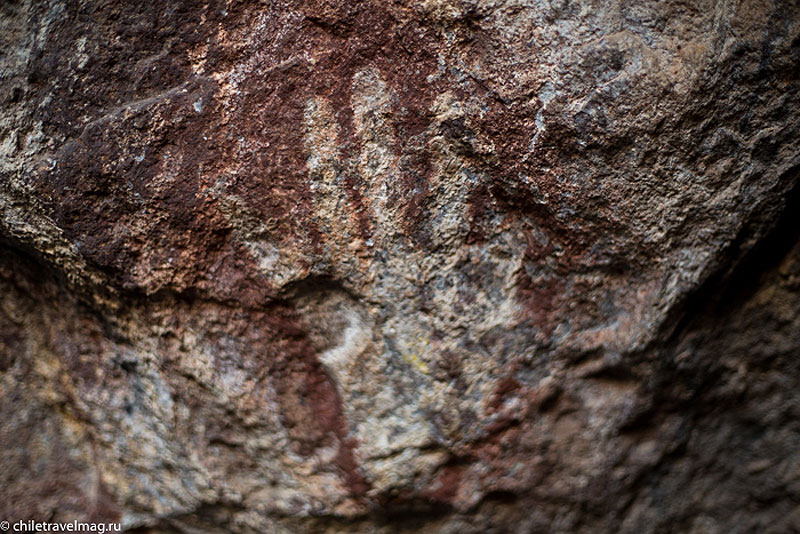
A tourist route of extraordinary beauty stretches from the city of Puerto Montt to the Aisen region through national parks. Here is the blue bowl of Lake General Carrera, caves near the town of Chile Chico with unusual rock artefacts—handprints of the Tehuelches Indians—on the way to which you may not meet other travellers for three hours; the confluence of the fast rivers Neff and Baker, two shades of turquoise, is considered an ideal place for rafting. But the main tourist attraction is the marble grottoes of Capillas de Marmol. The rugged rock stretches along the lakeshore for tens of kilometres. On excursion boats and kayaks, you can get close to the grottoes and even slip into the patterned arches, the rich blue colour of which is difficult to believe until you understand—the marble obediently reflects the colour of the water of the lake, filled with melting glaciers.
In small towns, you can still see elderly men on the streets dressed like gauchos, with a silk neckerchief, cap, leather bomber jacket and cowboy boots. The main accessory of such a senior is a round calabash vessel with a bombilla straw through which they sip mate.
One of the new parks in the region is called Patagonia. It consists of lands that belonged to the American entrepreneur Douglas Tompkins and were transferred to the state by his widow. The closer to the fjords in the Los Lagos area, the more capricious the climate and the more rain - as in the vicinity of Puyuapi, a town built by the Germans who sailed from the island of Chiloe. On the other bank, in the thicket of an endemic forest, there is a hotel of the same name, which can be reached by crossing once a day. The reward will be a digital detox without communication, an open-air thermal pool and a serene view of the fjord. Here the author once met tiny Pudu fawns that had come down from the mountains to escape pumas.
Temperate rain forests, the “cold selva” or “Valdivian forest,” are found only in Chilean Northern Patagonia. Giant ferns, gunners, and orange arrayana trees give the forest a fabulous look. Rarely does a day go by without rain here.
In these parts, immigration was predominantly German. Echoes of Vaterland culture are noticeable in the development of brewing, the ubiquitous “kuchen” pies on the menu, and half-timbered houses.
As you move higher on the map, you see volcanoes more and more often. Chile is one of the top five countries in terms of the number of volcanoes on its territory. If the highest, including the world record holder, almost seven thousand meters high Ojos de Salado, are located in the desert in the north, the most active volcanoes are scattered in the south from Los Lagos to Araucanía, the land of the Mapuche Indians. The obstinate Villarrica, whose crater constantly smokes like a furnace in the house of hospitable hosts (the name translates from the Mapudungun language as “house of spirits”), towers over the city of Pucon, which is awarded the World Travel Award year after year as the best destination for active tourism. National parks with routes for trekking, volcano climbing, kayaking, rafting, and fishing—there is a wide choice. Sports recreation is successfully complemented by complexes with open-air thermal springs, where you can recuperate.
The Chileans themselves invariably come to Northern Patagonia for their summer holidays, which take place in February. The season starts in December, and if you arrive early, the whole world will be yours.


